
Over the years I have acquired a fair number of old engravings, photographs and postcards of Largs. These mostly relate to the Edwardian era into the 1930s and in this article I will attempt to present an album of captioned pictures to give a sense of the town and some of the events that distinguish it. The account covers little beyond the second world war. Largs had two excellent photographers who produced postcards during the early and middle part of the 20th century; Hampton, and Simpson. Both feature strongly in what follows. Simpson also published copies of earlier photographic work by Poulton. Another important photographer was Fergus who, in addition to portraits, also included views of the town.

I will start with some early views from engravings and phtographs taken from paintings, moving into the photographic era with more specific topics. In the early years, the main part of the town lay between the Gogo Water to the south and the Noddsdale Water to the north. South of the Gogo lay Broomfields, and the site of the Battle of Largs where the Vikings under King Haco were defeated in 1263. The southern expansion of the town began with the construction of villas in the early 1800s as the popularity of the resort increased. To the north, development was slower. Largs pier was built in the early 1830s and the pierhead provides a good central point for the album.

Largs in the 1830s (Simpson)

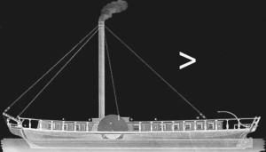
Largs in 1845 with the Lady Brisbane (Simpson)

Largs in the 1850s (Young)

Largs in the 1850s. The structure in the foreground is an artillery battery at the north end of the Esplanade (Banks)

A view from the Pierhead of the hotels on the seafront about 1890 (Simpson)
The street along the seafront from the pierhead is the main road to Greenock, and the part in town is known as the Gallowgate. The earliest photographs included here show St. Columba’s Parish Church, that occupied the site at the foot of Nelson Street and was built around 1812, before the first steamboats reached the town. An earlier Church, also dedicated to St Columba, fell into ruin around 1800, and all that remains is the Skelmorlie Aisle in the old graveyard north of the Main Street and east of the Gallowgate. Closer to the pier there were hotels and boarding houses catering to the needs of visitors who came to take the waters. In front of the houses is an excellent esplanade—Victoria Esplanade—and along the shoreline, close the harbour, is where visitors and residents could purchase fish, or hire a boat, at the numerous fish-boxes and boat-hirers huts.

Largs from the north in 1872 showing the old Parish Church at the foot of Nelson Street (Valentine)

Harbour and Fish Boxes in 1878 (Valentine)
Around 1892, the old parish church was replaced by an imposing new structure, also called St. Columba’s

The new St Columba’s Parish Church in the 1890s (Poulton)

Largs sea-front in the 1890s with fish boxes and boat hirers next to the harbor groyne and Gallogate Square on the right (Poulton)

Victoria Esplanade in the 1890s taken from the spire of the UP Church (Fergus)

In the 1900s, the fish-boxes were removed and boat-hirers took over

The height of the season was good for business (Hampton)

Largs Bay from the Pier

The Esplanade was also used for Largs Fair on St Colum’s Day

Trips around the Bay on a motor boat were introduced before the first world war

Largs Bay before the first world war (Simpson)

The bathing beach in the 1920s

A pavilion with facilities for bathers was built on the bathing beach esplanade around 1930 and can be seen in this 1932 view (Judges)

In 1936, Nardini’s Cafe was opened at the foot of Nelson Street (Valentine)

Nardini’s Cafe became a feature of the sea-front

A favorite view for many postcards

By the late 1930s, motor boats were providing many excursions

As motor-traffic increased, part of the esplanade was used as a car-park

Set back from the Main Road, Cochrane Place later became the Brisbane Hotel (Hampton)
The farthest extent of the Esplanade to the north was near Aubrey Crescent where there were hotels and boarding houses commanding fine views of Largs Bay and the town.

Wavecrest Boarding House and Aubrey Crescent (Lilywhite)

Wavecrest Boarding House and Aubrey Crescent (Simpson)

Largs from Aubrey Crescent in the 1920s
Inland, fine walks were to be had following the Noddsdale Burn up Brisbane Glen Road into the Renfrewshire Hills.

Walking on The Glen Road (Hampton)

The Glen Road (Hampton)
On the north side of the Burn was Netherhall, once the home of William Thompson, perhaps better known as Baron Kelvin of Largs. The house later became a Christain Guest House, and is now flats.

Netherhall (Poulton)

Further up the Noddsdale Burn was Brisbane House, the home of the Brisbane family. It was finally demolished during the second world war by No. 3 Commando, based at Largs for training (Poulton)

Tourgill Falls, a picturesque destination in Brisbane Glen (Judges)

A Farm Cart on the Glen Road

Baker’s Van
The Hills Hotel in the foothills dates from the Victoria era. It became part of a sports centre but was eventually knocked down.

The Hills Hotel (Simpson)
Coming back towards the town center along Brisbane Road there is an interesting glimpse into the diverse architectural styles that can be found in the town

Cottages on Brisbane Road where it intersects Brisbane Street (Hampton)

The unusual curves of Seamore Street to the east of Brisbane Road (Simpson)

Nelson Street running from west to east from the Esplanade where Nardini’s Café is situated next to St Columba’s Parish Church. (Hampton)
Returning to the pierhead where the Main Street leads through the town.

A view from the pier of the Pierhead and Main Street in the 1920s. On the Pierhead to the left is the steamer booking office. Is that an amphibious car in the harbour?

Booking Office of the Caledonian Steam Packet Co. and Glasgow and South-Western Railway on the Pierhead (Davidson)

A view east on Main Street from the Pierhead. The Moorings restaurant was a notable fixture of Largs for many years. Dating from 1936 and with a nautical theme in its design, it was owned by the Castelvecchi family who had a smaller café on the same site previously. A cruise on the Caledonian turbine Duchess of Argyll is advertised

The advertisement in this view is for a cruise to Lochgoilhead on the London & Northeastern steamer Jeanie Deans in the late 1930s

Moorings restaurant in the 1950s. It was demolished in 1989 and replaced by a new building.

Main Street from the pierhead in the 1920s

An early view of Largs Main Street from the Pierhead

An 1890s view looking east from the Pierhead along the Main Street (Poulton)

Accessible by a lane on the left is the old burying ground and the Skelmorlie Aisle, all that remains on an early Parish Church demolished around 1800 (Poulton)

The Syvers, an open drain fed by burn water, in the Main Street in 1883.

The Old Post Office in the Main Street in 1884 (Simpson)

The Post Office on Main Street moved location several times over the years. In this view from around 1910, it is located at the corner of Bellman’s Close (Kirk Close)

The Chanty Dyke in the Main Street at Piper Row, now Aitken Street, that was demolished in 1894 (Simpson)

The Glasgow & South-Western Railway reached Largs in 1885, more than forty years after towns such as Greenock and Ayr had their railway connections. Prior to that date, most visitors arrived by steamboat.

The station facade on the Main Street around 1920.

Looking to the Pierhead from the station in the 1920s. The Picture Pavillion was offering a Matineé at 3 p.m. every wet day. The entrance to Robertson’s Motor Garage is by Bellman’s Close.

Another view to the Pierhead from the corner of the cafe in the previous photograph. The photograph dates from the 1920s

A view to the Pierhead from across the street in the early 1950s (Valentine)

Yuill’s old barbershop, the last thatched building on the Main Street, in the 1890s (Simpson)
Looking from the Pier to the South, the Alexandra Esplanade extends from the Pierhead along Fort Street.

Fort Street from the Pier around 1920 (Simpson)

Alexandra Esplanade and Fort Street in 1932. On the right below the lower spire is the Bath Hall built to improve the personal hygiene of the populace in 1816 (Judges)
The skyline is dominated by two spires. The smaller of these belongs to the Free Church, built in 1886.

The Free Church (Poulton)
The tall spire belongs to the Clark Memorial Church, built for the United Presbyterians around the same time, 1892, as the Parish Church to the north.

Clark Memorial Church (Poulton)

The Free Church and Pier from Alexandra Esplanade. The round building in the center of the photograph is the end of the Bath Hall

The Pier with the steamer Queen Empress in the 1920s
Despite its sheltered location, Largs was subject to storms. With heavy rain on the adjacent hills, low atmospheric pressure and high tides led to frequent flooding.
On February 17, 1910, the seafront was buffeted by an impressive storm that brought flooding to the Main Street and the surrounding area.

The Alexandra Esplanade on February 17, 1910

Looking down a flooded Bath Street with the Bath Hall at the far end on February 17, 1910
Later in the year, on August 20, heavy rain caused the Noddsdale and Gogo burns to overflow.

Glen Road flooded on August 20, 1910
Such was the force of the water in the Gogo burn that the bridge nearest the mouth of the stream was washed away.

The collapse of the Gogo Bridge on August 20, 1910
The Main Street and Bath Street were again flooded on November 5, 1911.

Flooding on the Main Street looking to the Pierhead with Bath Street on the left on November 5, 1911 (Simpson)
Just over a year later, on November 26, 1912, another severe storm struck Largs, damaging parts of the Esplanade and causing flooding in the Main Street and Bath Street.

Alexandra Esplanade on November 26, 1912 (Hampton)

Another view of Alexandra Esplanade on November 26, 1912 (Hampton)

Looking up Bath Street to the Main Street on November 26, 1912 (Simpson)

The Pierhead from the flooded Main Street on November 26, 1912 (Hampton)

Assessing the damage at the Pierhead on November 29, 1912 (Simpson)

Damage the Alexandra Esplanade on November 29, 1912 (Simpson)

Another storm on November 5, 1914 from Aubrey Crescent (Hampton)

Flooding was a recurrent problem. In this case a bus makes its way into the Main Street at the Pierhead in 1934

Winter in Largs could bring heavy snow. This is the Main Street

Snow along the Gallowgate

Heavy snow in 1940 at Gallowgate Square

Snow in the winter of 1949
The Alexandra Esplanade continues south, meeting Union Street.

Union Street with Seaview on the right. Seaview became a Girls Friendly Society Home in 1888, and was used to provide short periods of respite to over-worked shop-girls from Glasgow and other cities.

Seaview abutted the extension of Sandringham Terrace. The original Terrace was completed in 1906 and extended in subsequent years. (Hampton)

The Green in front of Sandringham was the site of the Memorial to the fallen of the first world war, dedicated in September 1921

The War Memorial, looking out to sea in 1932 (Judges)

South of Sandringham is Gogo Street runing along the bank of the Gogo Water

Gogo Street and the Gogo Water. Note the Railway Bridge

The bed of the Gogo Water is strewn with large boulders giving some idea of its power in spate (Judges)

Upstream is Hawkhill, built in 1815 as a stable-block and sold to John Scott (Poulton)

Gogo sawmill powered by a lade on the bank go the burn (Hampton)

A placid scene on the Gogo (Judges)

The Gogo burn could prove treacherous in spate

Remnants of the Gogo Bridge destroyed in the flood of August 20, 1910

The new Makdougal Brisbane Bridge opening on March 30, 1911 (Hampton)

The new bridge with the south facade of Sandringham in the background

The new Makdougal Brisbane Bridge looking to Mackerston Green

The Mackerston Green featured the Campbell Fountain, named after a local physician. On the right is a large villa known as the Castle (Poulton)

Mackerston Green was groomed as a putting green, while to the south a model yacht pond was a favorite of young and old. This view is from 1948 (Valentine)

The putting green looking towards Sandringham

The putting green with the Campbell Fountain and Sandringham in the background

Mackerston putting green with Jeanie Deans heading for the pier in 1936

The model yacht pond at Mackerston looking north

The model yacht pond looking south in the 1930s

Duchess of Fife on her way to Millport, passing the model yacht pond and the prominent ice-cream kiosk of the Castelvecchi family

South of Mackerson Green is Broomfield’s and in the upper part, John Street stretching to the east from the railway bridge (Simpson)

The eastern end of John Street (Simpson)

Beyond the Mackertson Green on the foreshore is the Cadet Stand Pavilion, a popular entertainment venue at the time.

Happy crowds at the Cadet Stand Pavilion in August 1910

The crowd filling the slope up to Upper Broomfields

The Curling Hall was built in 1813 by Dr John Cairnie, and enthusiastic curler, and featured his own curling pond. It was later purchased by Mr John Clark of the Anchor Thread Mills, Paisley, who had the Clark Memorial Church built at his expense (Poulton)

The Curling Hall became a hydro-hotel in 1920

Adjacent to the Curling Hall is Barra House, built in the early 1830s and turned into a hotel after the first world war. It was later renamed the Marine Hotel

In 1953, the Marine and Curlinghall were joined together. The spectacular venue was demolished in the early 1980s

South of Barra House were several prominent villas; Littleraith, built in the 1820s, Clifford Lodge, and Crescent Lodge (Fergus)

Upper Broomfields around 1905 (Stengel)

Broomfields

The path leads south to Bowen Craig and the Battle of Largs Memorial (Judges)

Battle of Largs Memorial, locally known as the “pencil”, looking ver to Fairlie (Judges)

Battle of Largs Memorial (Judges)
Extending into the hills behind Largs is Douglas Park with its tennis courts. The climb into the hills is arduous but the reward is a magnificent view over the Cumbraes.

Entrance to Douglas Park

Tennis Courts in Douglas Park (Valentine)

133 Steps on the climb into the hills in Douglas Park

On the Hill, Douglas Park (Judges)

The spectacular view of the town from the top of the climb (Simpson)

On the upper hillside, the isolated “Cock-ma-lane” features on many postcards (Judges)

Greeto Bridge in the headwaters of the Gogo Burn.
The L-shaped Pier at Largs and the harbour it enclosed were perhaps the most important features of the resort.

Largs Harbour and Pier from the Victoria Esplanade (Davidson)

The Pier from the south

Motor boats in the Harbour (Judges)

Crowds on the Pier awaiting an approaching steamer. When there was more than one steamer, the tower with the circles (three showing to the south and three also on the opposite face to the north) was used to signal which of the approaching steamers (shoreward, middle, or seaward) should first approach.

Queues form for the cruise steamers around 1950
Visits by the Navy, anchoring in Fairlie Roads, were common before the first world war.

Sailors from H.M.S. Dominion leaving Largs

H.M.S Monarch off Largs with a large crowd on the Pier

H.M.S Monarch anchored in Fairlie Roads
The annual regatta at Largs attracted a considerable following.

Largs regatta in the early 1870s. The steamer at the pier is the Levan, built for the Greenock & Helensburgh Company in 1866 but sold when the company collapsed a few years later (Simpson)

Glasgow & South-Western steamer Juno at Largs during a regatta around 1910 (Simpson)

Largs from the sea during the regatta around 1910 (Simpson)

The yacht Lady Anne off Largs (Simpson)

Caledonian Steamer Marchioness of Lorne weaves through the yachts at the regatta (Simpson)

Lord Inverclyde’s steam yacht Beryl at Largs Regatta. She was later burned on the Gareloch by suffragettes (Simpson)

Beryl at Largs with the yacht Valkyrie (Davidson)

The Royal Yacht, H.M.Y. Victoria and Albert at Largs regatta
Over the years, many steamers had strong associations with the Largs and Millport trade.

Before the railway reached Largs, travel to the town was by steamer. Here Lancelot, built in 1868, is arriving from the railhead at Wemyss Bay in the 1870s.

The Glasgow & South-Western had a rail-link to Largs in 1885 and when the Caledonian Railway took over the Wemyss Bay Railway a few years later, it was the Caledonian Steam Packet Co., Ltd. that took over the sailings to Largs and Millport. The Madge Wildfire, with her buff funnel, awaits departure for Wemyss Bay. (Stengel)

Caledonia, approaches Largs Pier in the 1890s (Poulton)

Caledonia heading for a Wemyss Bay train connection (Simpson)

Marchioness of Lorne was a familiar sight before the first world war (Simpson)

Marchioness of Lorne heading for Millport

Marchioness of Lorne leaving for Wemyss Bay (Poulton)

Marchioness of Lorne in the gloaming

Visitors to Largs were offered cruises to destinations around the Firth of Clyde. The pioneer turbine, King Edward, calling at Largs in 1900s (Simpson)

The well-laden Glasgow & South-Western turbine, Atalanta, of 1906, at Largs (Simpson)

Evening Cruises were also popular. Here, a Caledonian Duchess loads at the pier while the Turbine, Queen Alexandra, back from her day excursion to Inveraray, waits to pick up passengers for an evening cruise (Simpson)

The Caledonian, Marchioness of Breadalbane, at Largs, loading for Millport and Kilchattan Bay on Bute in the 1900s (Simpson)

During the first world war, most of the Caledonian fleet of steamers were taken as minesweepers and the Company chartered older vessels. The Benmore was placed on the Largs and Millport sailing from Wemyss Bay with her funnel painted in the Caledonian colours

Benmore at Largs Pier in 1918-19

Benmore leaving Largs for Millport in 1918-19

As the Caledonian steamers returned from military duties, there was a rush to recondition them for civilian service. In 1919, Marchioness of Breadalbane appeared on the Largs and Millport service with her paddle-boxes painted black. Marchioness of Lorne was scrapped.

The normal color scheme was reapplied in 1920 (Judges)

Marchioness of Breadalbane at Largs in the early 1920s (Judges)

South-Western turbine, Atalanta, leaving Largs in the early 1920s (Simpson)

Queen Empress leaving Largs in the early 1920s (Simpson)

In 1923 the Caledonian and South-Western Companies were amalgamated under the London, Midland and Scottish Grouping, and the steamers appeared with yellow, black-topped funnels with a red band as in this photograph of the Duchess of Argyll at Largs. The red band was dropped in 1925

Marchioness of Breadalbane approaching Largs after 1924

The Largs and Millport service continued throughout the year and stormy weather rarely resulted in missed sailings. A north-westerly gale has forced Marchioness of Breadalbane to berth on the south wall of the pier as she is maneuvered at Largs in the 1920s

Cruising out of Largs remained popular into the 1960s. Duchess of Argyll loads a crowd in 1928

Queen Mary II approaches Largs in 1939 (Valentine)

Queen Mary II at Largs in 1948

Queues for Marchioness of Graham in 1952

From the mid-1930s, the summer service to Millport was augmented with motor vessels. Here Leven approaches the pier in the 1950s

Ashton at the Pier in 1957. Ashton and Leven were built for cruising on the upper river for the 1938 Empire Exhibition but displaced the original motor vessel, Wee Umbrae, on the Millport route

Countess of Breadalbane at the pier in the 1950s.

Keppel at the pier in the 1970s

King Edward in 1950
R. & M. McSherry, “Old Largs,” Stenlake, Ochiltree, 1997
A. M. Brown, “Largs and District in Old Postcards,” European Library, Zaltbommel, 1987
R. Close, “Ayrshire & Arran,” Royal Incorporation of Architects in Scotland, Edinburgh, 1992
January 5, 2024
Brilliant pictures, love seeing the history of such a great town. Have you anything related to Nelson House, 2 Nelson Street between Nardinis and the church, we brought the house just over 5 years ago. Thanks Rick
January 5, 2024
I’m afraid I have only the posted photograph of Nelson Street. I have however seen postcards of what looks like the end of Nelson Street elsewhere. I will see if I can obtain a copy. Graham
January 5, 2024
A wonderful collection of photographs..thank you.
Would you have any of the old farms around Largs such as Holehouse, Flatt and Harplaw?
January 5, 2024
Joanna: Thanks for the comment. I have a few photographs of the surrounding countryside but none of the farms. Graham
January 5, 2024
Another excellent trip down memory lane.
Never realised that the town was so battered by storms and flooding in the past – obviously global warming….
January 9, 2024
Great collection of pictures and info, brings back many memories. Thank you for sharing, is there a print version available?
January 9, 2024
Ian: I’m afraid there is no print version. You could always print them off.
April 10, 2024
What an excellent collection of images! Do you happen to have any photos of the houses that were built on Brisbane Street? Ours was built around 1910.
February 6, 2025
Thanks for posting so many wonderful good-quality views of Largs. Nice to see what has changed and what has stayed the same since Victorian days. Well done!
November 2, 2025
Wonderful collection of photos and it obviously involved a great deal of research. I learned a great deal about my home town from your posting. Many thanks for your efforts .
November 2, 2025
Duncan: Glad you found it interesting. Graham